Balatonszentgyörgy - Vörs Kilato - Balatonbereny ( Balaton Ungarn )
medio
Navegue por
Navegue por
Consigue este tour en tu móvil
Balatonszentgyörgy - Vörs Kilato - Balatonbereny ( Balaton Ungarn )
medio
Ciclismo
40,88
km
Escanee el código QR e inicie la navegación en la aplicación bergfex

Senderismo y rastreo


Balatonszentgyörgy - Vörs Kilato - Balatonbereny ( Balaton Ungarn )
medio
Distancia
40,88
km
Duración
03:30
h
Ascenso
86
m
Nivel del mar
103 -
131
m
Descarga de pistas
Balatonszentgyörgy - Vörs Kilato - Balatonbereny ( Balaton Ungarn )
medio
Ciclismo
40,88
km
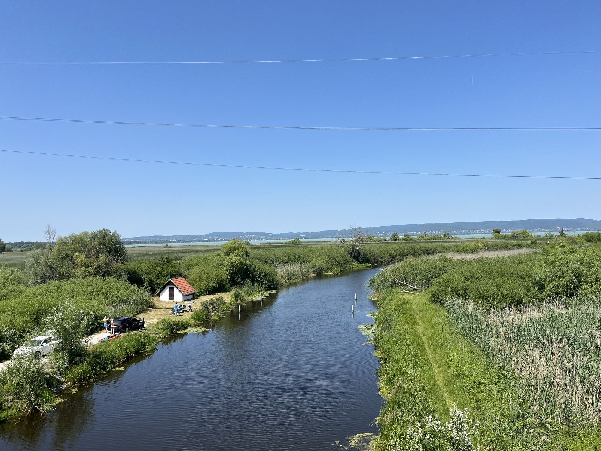
Rundfahrt von Keszthely über Balatonszentgyörgy nach Vörs - Kilato ( Aussichtsturm ) und Balatonbereny ; zurück auf Balaton-Radweg nach Keszthely ( Balaton Ungarn ) Markierung: "K1" Start: KESZTHELY...
Descripción de la
Rundfahrt von Keszthely über Balatonszentgyörgy nach Vörs - Kilato ( Aussichtsturm ) und Balatonbereny ; zurück auf Balaton-Radweg nach Keszthely ( Balaton Ungarn )
Markierung: "K1"
Start: KESZTHELY Stadt-Mitte / Hotel Helikon
- von Keszthely-Zentrum auf markiertem Radweg "K3" nach Süden bis Fenekpuszta
- nach Fenekpuszta links ab über den Fluss Zala nach Balatonszentgyörgy
- in Balatonszentgyörgy rechts ab bei Eisenbahnkreuzung ca. 5 km bis Vörs
- in Vörs bei Kirche rechts ab über Eisenbahn noch ca 1,5 km bis zum Vörs-Kilato ( Aussichtsturm )
- wieder nach Vörs, rechts weiter über Battyanpuszta nach Balatonbereny
- zurück am Balaton-Radweg von Balatonbereny nach Keszthely
- Ziel: KESZTHELY Stadt-Mitte / Hotel Helikon
Ruta
Keszthely
(114 m)
Ciudad
0,1 km
Masni Piknikkert
(118 m)
Restaurante
3,1 km
Szent Márton püspök-templom
(117 m)
Lugar de culto
13,8 km
Szent Márton püspök-templom
(117 m)
Lugar de culto
16,9 km
Szent György-templom
(124 m)
Lugar de culto
22,6 km
Keresztelő Szent János-templom
(125 m)
Lugar de culto
25,5 km
Keszthely
(114 m)
Ciudad
39,5 km
Ruta
Balatonszentgyörgy - Vörs Kilato - Balatonbereny ( Balaton Ungarn )
medio
Ciclismo
40,88
km
Keszthely
(114 m)
Ciudad
0,1 km
Halászcsárda
(108 m)
Restaurante
1,4 km
Pedro steak house
(109 m)
Restaurante
1,5 km
Pepi Vendéglő
(110 m)
Restaurante
1,5 km
Masni Piknikkert
(118 m)
Restaurante
3,1 km
Szent Márton püspök-templom
(117 m)
Lugar de culto
13,8 km
Vörs
(112 m)
Pueblo
14,0 km
Szent Márton püspök-templom
(117 m)
Lugar de culto
16,9 km
Vörs
(112 m)
Pueblo
17,4 km
Battyánpuszta
(121 m)
Liquidación
18,7 km
Szent György-templom
(124 m)
Lugar de culto
22,6 km
Piki Étterem és Élelmiszer
(117 m)
Restaurante
22,7 km
Balatonszentgyörgy
(113 m)
Pueblo
22,7 km
Balatonberény
(120 m)
Pueblo
25,4 km
Keresztelő Szent János-templom
(125 m)
Lugar de culto
25,5 km
Masni Piknikkert
(118 m)
Restaurante
36,0 km
Pepi Vendéglő
(110 m)
Restaurante
37,1 km
Pedro steak house
(109 m)
Restaurante
37,6 km
Halászcsárda
(108 m)
Restaurante
37,8 km
Múzeum játszótér
(122 m)
Parque infantil
38,8 km
Keszthely
(114 m)
Ciudad
39,5 km
Compartir gira
Balatonszentgyörgy - Vörs Kilato - Balatonbereny ( Balaton Ungarn )
medio
Ciclismo
40,88
km
Error
Se ha producido un error. Por favor, inténtelo de nuevo.


Último seguimiento
3 hace semanas
Información sobre la ruta
Parada de descanso y avituallamiento
Vörs Kilato (Aussichtsturm); Balatonbereny
Hermosa vista
Sí
Información adicional y consejos
Neumáticos de carretera
Sí
Neumáticos todoterreno
Sí
Aún no hay opiniones
Rutas populares en los alrededores
-
5,0
Rundfahrt mit Schiff über Balatonmariafürdo - Balatongyörög ( Balaton Ungarn )
medioCiclismo 33,6 km -
Heviz Tófürdő - Thermalbadesee ( Balaton Ungarn )
luzCiclismo 16,9 km -
Keszthelygebirge - Bakonyerdö - Pad-Kö Kilato - Szépkilátó ( Balaton Ungarn )
medioMountainbike 35,6 km -
Ruine Burg Rezi Var Panorama ( Balaton Ungarn )
medioMountainbike 15,7 km -
Keszthely Festetics Kilato Panorama ( Balaton Ungarn )
luzCiclismo 13,4 km -
Balatonmagyaród Gehen
Pasear 5,31 km -
Keszhelyi - hg tele kalandal
pesadoMountainbike 52,6 km -
4,0
Balatonberény, Dél-Dunántúl/Magyarország
Senderismo 10,4 km -
5,0
Balatongyörök - Garga-hegy - Batsányi-kilátó
luzSenderismo 4,91 km -
Keszthely Gehen
Pasear 4,27 km
Senderismo y rastreo

Más de 550.000 sugerencias de excursiones, mapas detallados y un intuitivo planificador de rutas hacen de esta aplicación una herramienta imprescindible para todos los amantes de la naturaleza.

No se pierda las ofertas y la inspiración para sus próximas vacaciones
Suscribirse al boletín de noticias
Error
Se ha producido un error. Por favor, inténtelo de nuevo.
Gracias por inscribirse
Su dirección de correo electrónico se ha añadido a la lista de correo.
Viajes por Europa
Austria
Suiza
Alemania
Italia
Eslovenia
Francia
Países Bajos
Belgium
Polonia
Liechtenstein
República Checa
Slovakia
España
Croacia
Bosnia y Herzegovina
Luxemburgo
Andorra
Portugal
Iceland
United Kingdom
Ireland
Greece
Albania
North Macedonia
Malta
Norway
Montenegro
Moldova
Kosovo
Hungary
San Marino
Romania
Estonia
Latvia
Belarus
Cyprus
Lithuania
Serbia
Bulgaria
Monaco
Denmark
Sweden
Finland