


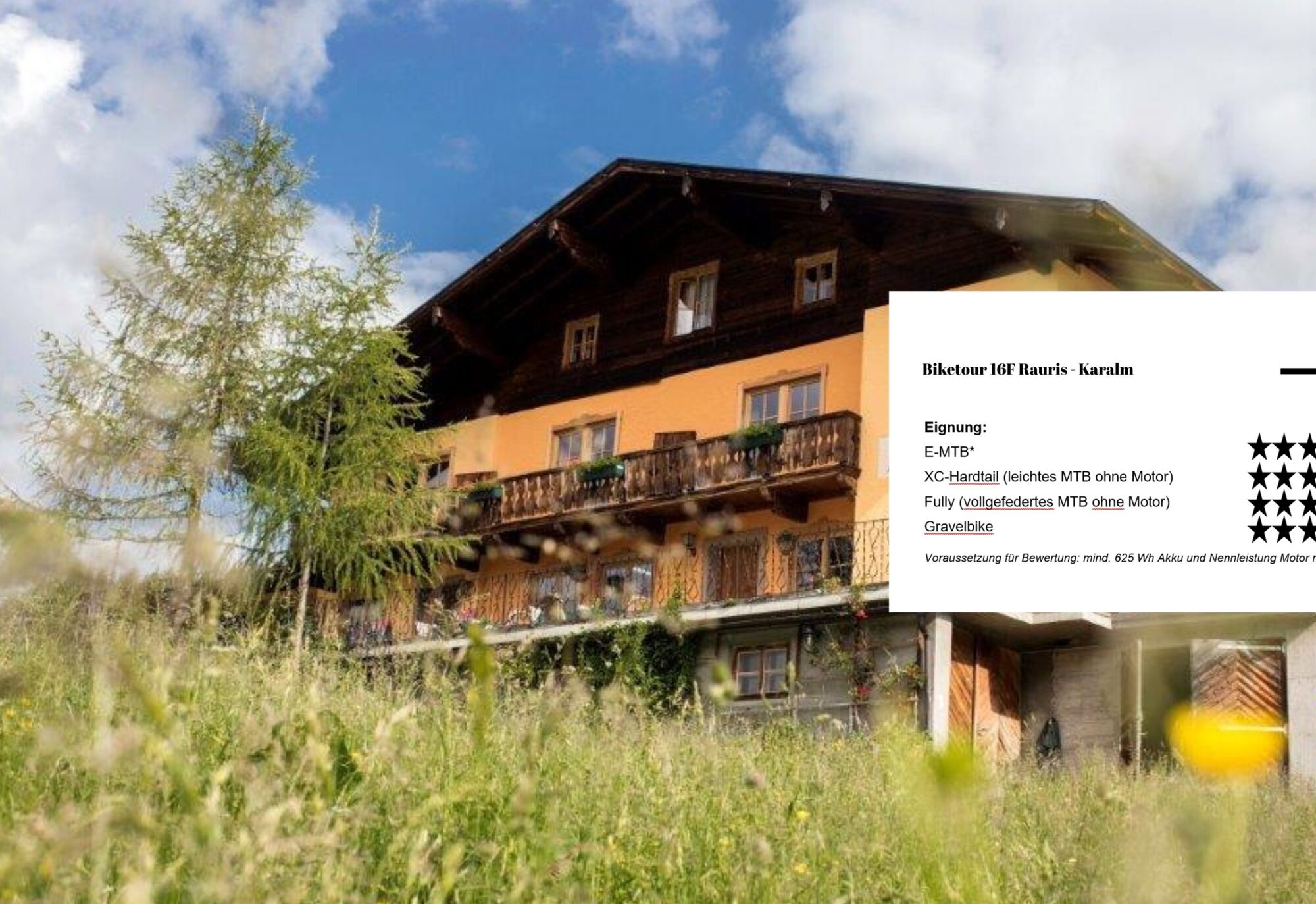
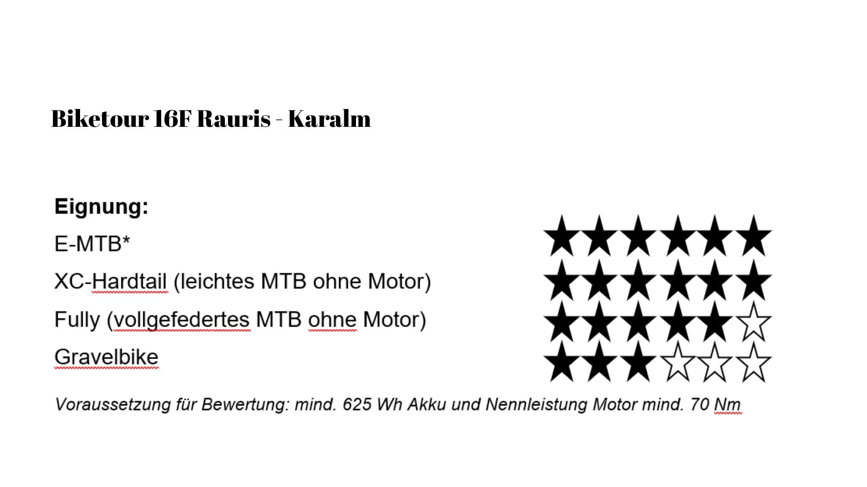
NP 16F | Ruta de ciclismo de montaña Karalm en el valle Raurisertal
Un hermoso camino para bicicletas desde el centro de Rauris te lleva al valle Gaisbachtal hasta la Karalm.
El camino forestal sube ligeramente desde el principio y al final de esta ruta de ciclismo de montaña...
Un hermoso camino para bicicletas desde el centro de Rauris te lleva al valle Gaisbachtal hasta la Karalm.
El camino forestal sube ligeramente desde el principio y al final de esta ruta de ciclismo de montaña llegarás a la acogedora Karalm, desde donde tienes una vista impresionante.
Como el camino siempre sube, se necesita buena condición física.
Pero el recorrido realmente vale la pena.

After a short ride on the asphalt road, you reach the forest road in Gaisbachtal after about 15 minutes. At the beginning still a bit steeper, it becomes slightly less demanding over time, but always gently ascending to the Karalm.
From the town center, you start cycling towards Gaisbachtal and follow the paved road into the valley. After about 15 minutes, the forest road (gravel) begins. Right at the start awaits a steeper climb section, which challenges you noticeably in the first few minutes and quickly gains altitude.
After a few altitude meters, the route continues uphill but the incline becomes much more moderate and steady – ideal for finding a good pedal stroke and keeping the rhythm.
You ride into the original Gaisbachtal, accompanied by forest sections, the flow of the brook, and repeatedly beautiful views of the surrounding mountains.
The path continues diversely through the natural landscape until you finally reach the Karalm – a worthwhile destination for a pleasurable break before returning to the valley.
Sí
Sí
Note: A small parking lot on the left side, starting from the forest road in Gaisbachtal, is available.
At the beginning of the forest road, there is a small parking lot on the left side of the road.
https://www.raurisertal.at/de/sommer/aktiv-im-sommer/weitere-aktivitaeten/
Further tip:
This bike route is also simultaneously the flower trail with flower information boards along the route to the Karalm.
Actividades a lo largo del recorrido

Rutas populares en los alrededores
-
4,9
Großarl: Aualm - Liechtensteinkopf - Aukopf - Schuhflicker - Schuhflickersee
medioSenderismo 5,84 km -
4,7
Großarl: Mooslehenalm – Niggeltalalm – Viehhausalm
medioSenderismo 5,44 km -
4,8
Höhenweg vom Grünen Baum bis Bad Hofgastein
luzSenderismo 7,92 km -
4,8
Punto destacado Kitzlochklamm Classic Runde
medioSenderismo 2,02 km -
4,7
Bad Hofgastein Bergbahn Parkplatz - Rastötzenalm Bad Hofgastein
medioMountainbike 16,9 km -
4,6
Bahnhof Bad Hofgastein nach Bahnhof Bad Gastein
medioSenderismo 13,0 km -
4,3
Wasserfall Bad Hofgastein
luzSenderismo 3,89 km -
4,7
Goldeggweng Hochleitenalm
luzSenderismo 2,92 km -
5,0
Großarl: Heukareck
medioSenderismo 12,5 km -
4,9
Rauris: Bucheben-Steinalm-Steinbockalm-Feldereralm nº 20
medioSenderismo 7,78 km
Senderismo y rastreo


No se pierda las ofertas y la inspiración para sus próximas vacaciones
Su dirección de correo electrónico se ha añadido a la lista de correo.