Route 3 violett
luz
Consigue este tour en tu móvil
Route 3 violett
luz
Senderismo
6,75
km
Escanee el código QR e inicie la navegación en la aplicación bergfex

Senderismo y rastreo


Route 3 violett
luz
Distancia
6,75
km
Duración
03:30
h
Ascenso
377
m
Nivel del mar
710 -
1.083
m
Descarga de pistas
Route 3 violett
luz
Senderismo
6,75
km
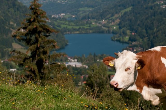
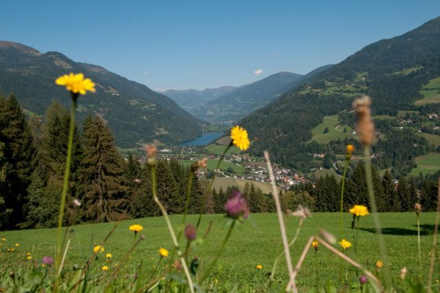
Abwechslungsreiche Wanderung von Afritz aus über malerische Wald- und Forstwege. Mit schönen Ausblicken und Einkehrmöglichkeiten, auch für Familien geeignet. Start: Afritz am See — Wanderweg # 28 nach...
Descripción de la
Abwechslungsreiche Wanderung von Afritz aus über malerische Wald- und Forstwege. Mit schönen Ausblicken und Einkehrmöglichkeiten, auch für Familien geeignet.
Start: Afritz am See — Wanderweg # 28 nach Verditz — Rainer — Schattenbergweg — Afritz Seeweg — Afritz -> 8,3 km 3,5h | Höhenmeter/upward slope 385 m
Ruta
Afritz am See
(702 m)
Pueblo
0,0 km
Scherzboden
(777 m)
Liquidación
4,7 km
Kraa
(748 m)
Liquidación
5,8 km
Afritz am See
(702 m)
Pueblo
6,6 km
Ruta
Route 3 violett
luz
Senderismo
6,75
km
Autor
Proporcionado por Tourismusverein Verditz e.V.
Creado el 11. abril 2013
3.851
Llamadas
Error
Se ha producido un error. Por favor, inténtelo de nuevo.

Información sobre la ruta
Parada de descanso y avituallamiento
Sigis Einkehr
Adecuado para familias
Sí
Zona forestal
Sí
Equipamiento
Wanderschuhe
Información de llegada
Llegada
Afritz
Aparcamiento
Spar Markt Afritz
Valoraciones
Rutas populares en los alrededores
-
4,4
Cascadas de Finsterbach - Camino circular
medioSenderismo 3,87 km -
4,9
Ruta de 4 cabañas
medioSenderismo 8,96 km -
5,0
Amberg: Palnock 1901m, Schwarzsee, Rundstrecke
medioSenderismo 7,94 km -
4,9
Skitour: FIS K70, Auf Franz Klammers Spuren
medioEsquí de travesía 11,3 km -
4,0
Camino circular Schwarzsee
medioSenderismo 7,79 km -
3,9
Ruta ciclista del lago Ossiacher - R2 y R2A
medioCiclismo 28,2 km -
4,5
Wasserfälle
medioSenderismo 2,48 km -
4,5
Oswaldiberg St.Ruprecht
medioSenderismo 6,69 km -
4,0
Gerlitzen - sendero Hütter
pesadoSenderismo 6,80 km -
4,1
Mirnock
luzSenderismo 4,54 km
Senderismo y rastreo

Más de 550.000 sugerencias de excursiones, mapas detallados y un intuitivo planificador de rutas hacen de esta aplicación una herramienta imprescindible para todos los amantes de la naturaleza.

No se pierda las ofertas y la inspiración para sus próximas vacaciones
Suscribirse al boletín de noticias
Error
Se ha producido un error. Por favor, inténtelo de nuevo.
Gracias por inscribirse
Su dirección de correo electrónico se ha añadido a la lista de correo.
Viajes por Europa
Austria
Suiza
Alemania
Italia
Eslovenia
Francia
Países Bajos
Belgium
Polonia
Liechtenstein
República Checa
Slovakia
España
Croacia
Bosnia y Herzegovina
Luxemburgo
Andorra
Portugal
Iceland
United Kingdom
Ireland
Greece
Albania
North Macedonia
Malta
Norway
Montenegro
Moldova
Kosovo
Hungary
San Marino
Romania
Estonia
Latvia
Belarus
Cyprus
Lithuania
Serbia
Bulgaria
Monaco
Denmark
Sweden
Finland