Invierno
Verano
El tiempo
Webcams
Alojamientos
Excursiones
Historial de búsqueda
Sugerencias de búsqueda
No se han encontrado resultados
Buscar en
long-distance walking trail
Inicio
Verano Österreich
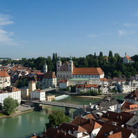
Alta Austria
Steyr und die Nationalpark Region
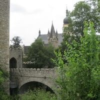
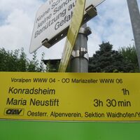
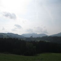
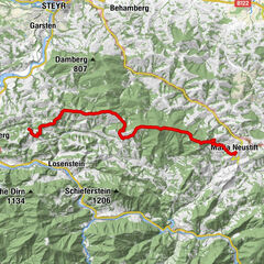
Maria Neustift
Excursiones
long-distance walking trail
Región
Alojamientos
El tiempo
Webcams
Consejos para el tiempo libre
Excursiones
Deporte
Fotos
Foro
Estación de esquí
long-distance walking trail
Maria Neustift
Mapa
mostrar
ocultar
Filtro de circuitos
Tipo de excursión
(Todos)
Senderismo (302)
Camino de peregrinación (20)
Sendero temático (7)
long-distance walking trail (3)
Walking (1)
Búsqueda de texto completo
Nivel
mín.
1 fácil
2 moderadamente
3 mediana dificultad
4 dificultad alta
5 muy difícil
6 extremo
máx.
1 fácil
2 moderadamente
3 mediana dificultad
4 dificultad alta
5 muy difícil
6 extremo
Técnica
mín.
1 fácil
2 moderadamente
3 mediana dificultad
4 dificultad alta
5 muy difícil
6 extremo
máx.
1 fácil
2 moderadamente
3 mediana dificultad
4 dificultad alta
5 muy difícil
6 extremo
Longitud (km)
Metros de altura
otros filtros
Buscar
Posponer
3 Excursiones.
ordenado por
Relevanz
Relevancia
längste Distanz
kürzeste Distanz
duración máxima
duración mínima
metros más verticales
menos metros verticales
alto estado
baja condición
alta tecnología
baja tecnología
Nombre A-Z
Nombre Z-A
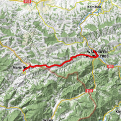
04 Voralpenweg, Etappe 09: Waidhofen - Maria Neustift
fácil
16,13
km
08:30
h
567
hm
356 - 745
m
Técnica
Nivel
OÖ Mariazellerweg Steyr - Maria Neustift
medio
23,95
km
05:05
h
1.189
hm
299 - 998
m
Técnica
Nivel
04 Voralpenweg, Etappe 10: Maria Neustift - Koglerhof
fácil
22,6
km
10:00
h
935
hm
514 - 980
m
Técnica
Nivel
Tous según tipos
Senderismo
Bike
Running
Invierno
Motorsport
Senderismo
Camino de peregrinación
Sendero temático
long-distance walking trail
Walking
Touren nach Regionen
Traunviertel
76
Steyr und die Nationalpark Region
27
Gipfeltouren in der Region
Spadenberg (1.000 m)
20
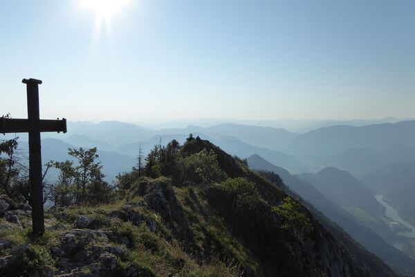
Schieferstein (1.206 m)
11
Lindaumauer (1.103 m)
15
Glasenberg (971 m)
11
Damberg (811 m)
33
Plattenberg (750 m)
12
Sonntagberg (716 m)
29
Weißes Kreuz (969 m)
7
Willeitenberg (837 m)
16
Burnerhöhe (356 m)
5
Excursiones opcionales por los alrededores
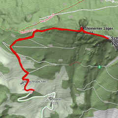
Schieferstein und Steinerner Jäger von Reichraming, Oberösterreich
medio
Senderismo
3,82
km |
726
hm |
02:30
h
Schieferstein via Reichraming
medio
Senderismo
7,03
km |
804
hm |
02:45
h
Steinerner Jäger - Schieferstein von Parkplatz Hochhabichler
medio
Senderismo
4,46
km |
413
hm |
02:03
h
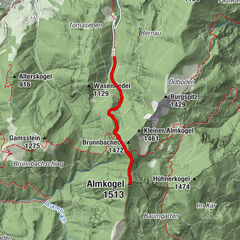
Ennser Hütte - Almkogel (via parking Bamacher)
medio
Senderismo
3,53
km |
709
hm |
01:50
h
Vecinos
Ertl
Großraming
Weyer
St. Peter in der Au
Seitenstetten
Regiones favoritas
Linz
Bad Ischl
Steyr
Gmunden
Bad Goisern
Wels
Mondsee am Mondsee
Altmünster
Vöcklabruck
Windischgarsten
Grünberg-Gmunden
Attersee am Attersee
Ebensee - Feuerkogel
Großraming
Ried im Innkreis
Freistadt
Kirchdorf an der Krems
Ternberg
Scharnstein im Almtal
Molln
Sorteo
Produkt-Paket für die ganze Familie
Primavera XXL-Gewinnspiel
No se han encontrado entradas.
La búsqueda no está disponible actualmente.
Afine su búsqueda.
Resultados de la búsqueda local
(<= 25km)
Más resultados
(> 25km)
%count% Resultados de búsqueda
%name%
%type%
%elevation%
%population%
%lpButton%