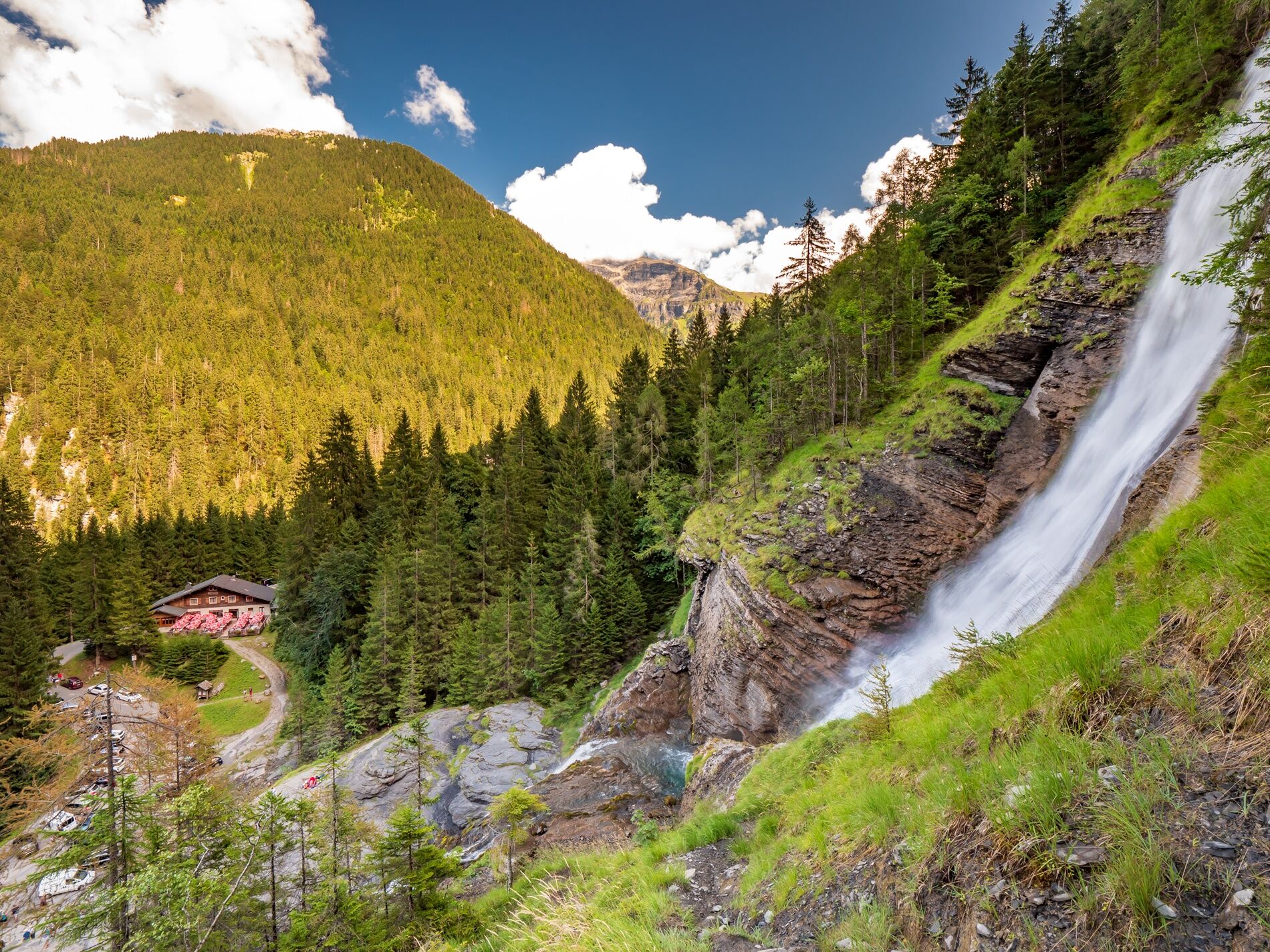
Walking itinerary: Rouget waterfall
luz
Navegue por
Navegue por
Consigue este tour en tu móvil
Walking itinerary: Rouget waterfall
luz
Senderismo
4,23
km
Escanee el código QR e inicie la navegación en la aplicación bergfex

Senderismo y rastreo


Walking itinerary: Rouget waterfall
luz
Distancia
4,23
km
Duración
01:30
h
Ascenso
178
m
Nivel del mar
815 -
948
m
Descarga de pistas
Walking itinerary: Rouget waterfall
luz
Senderismo
4,23
km
Difficulty: easy
Start: Salvagny (located next to Sixt-fer-à-cheval town)
From the parking lot, go along the road and then take the dirt road
immediately down to the right, below the parking lot.
of the parking...
Descripción de la
Difficulty: easy
Start: Salvagny (located next to Sixt-fer-à-cheval town)
From the parking lot, go along the road and then take the dirt road
immediately down to the right, below the parking lot.
of the parking lot. Find the GR5 itinerary and follow the direction
of the Cascade du Rouget. The path comes back to the road to cross the
to cross the torrent on the bridge. Continue, then after a few
meters, take a path on the left. The
trail goes up through the woods, crosses a small stream (bridge), then
(bridge), then go up on the RD. Continue along the road.
At the bend in the road, you can admire the Cascade du Rouget
which is suddenly revealed!
The return is done by the same route.
Itinerary for guidance only.
Ruta
Ruta
Walking itinerary: Rouget waterfall
luz
Senderismo
4,23
km
Autor
Proporcionado por Haut-Giffre Tourisme
El tour Walking itinerary: Rouget waterfall es proporcionado por outdooractive.com.
Compartir gira
Walking itinerary: Rouget waterfall
luz
Senderismo
4,23
km
Error
Se ha producido un error. Por favor, inténtelo de nuevo.

Información sobre la ruta
Ruta
1/ Du "parking du Nant Sec" situé à "Salvagny".
2/ Retrouver "l'itinéraire du GR5" et suivre la direction de "la Casace du rouget".
3/ Empruntez un sentier sur votre gauche. Le sentier remonte par les bois traverse un ruisseau et traverse "la RD". Continuez en longeant la voie.
4/ Pour le retour suivre le "même itinéraire".
Viaje de ida
Sí
Aún no hay opiniones
Rutas populares en los alrededores
-
4,0
Chamonix-Mont-Blanc, Auvergne-Rhône-Alpes/France // B/C
medioVía ferrata 2,59 km -
3,5
Lac d'Emosson - Gorge de la Veudale - Col de la Terrasse - Lac du Vieux Emosson zurück nach Lac d'Emosson
medioSenderismo 14,3 km -
5,0
Goldtoni - Alpenbogen A058 Auberge de Salanfe-Refuge de Chardonniere
medioSendero de largo recorrido 28,7 km -
5,0
2nd half of the cross- completed
medioTrailrunning 14,3 km -
Aiguille du Criou
pesadoSenderismo 16,7 km -
5,0
Goldtoni - Alpenbogen A060 Refuge Anterne-Chamonix
medioSendero de largo recorrido 19,6 km -
Ruta a pie: Refugio y pastizal de los fonts
luzSenderismo 7,66 km -
Recorrido de ARTE CONTEMPORÁNEO del Giffre // sendero «ARTE y NATURALEZA»
luzSendero temático 7,49 km -
Le tour - départ de l’olympique
medioRaquetas de nieve 2 km -
Le Tour/Balme 9-Miler
medioSenderismo 14,2 km

Senderismo y rastreo

Más de 550.000 sugerencias de excursiones, mapas detallados y un intuitivo planificador de rutas hacen de esta aplicación una herramienta imprescindible para todos los amantes de la naturaleza.

No se pierda las ofertas y la inspiración para sus próximas vacaciones
Suscribirse al boletín de noticias
Error
Se ha producido un error. Por favor, inténtelo de nuevo.
Gracias por inscribirse
Su dirección de correo electrónico se ha añadido a la lista de correo.
Viajes por Europa
Austria
Suiza
Alemania
Italia
Eslovenia
Francia
Países Bajos
Belgium
Polonia
Liechtenstein
República Checa
Slovakia
España
Croacia
Bosnia y Herzegovina
Luxemburgo
Andorra
Portugal
Iceland
United Kingdom
Ireland
Greece
Albania
North Macedonia
Malta
Norway
Montenegro
Moldova
Kosovo
Hungary
San Marino
Romania
Estonia
Latvia
Belarus
Cyprus
Lithuania
Serbia
Bulgaria
Monaco
Denmark
Sweden
Finland