The 2000 footpath around Fort de Ronce
medio
Senderismo
Navegue por
Navegue por
Consigue este tour en tu móvil
Mapa
The 2000 footpath around Fort de Ronce
medio
Senderismo
12,93 km
Escanee el código QR e inicie la navegación en la aplicación bergfex
QR Code
Senderismo y rastreo

The 2000 footpath around Fort de Ronce

Distancia
12,93 km
Duración
04:15 h
Ascenso
291 m
Nivel del mar
2.084 - 2.294 m
Descarga de pistas
Mapa
The 2000 footpath around Fort de Ronce
medio
Senderismo
12,93 km

Saint-Pierre chapel marks the beginning of your journey. The sounds of the alpine herds echo the marmots' whistles in the distance. The terrace of the 2000 trail seems to trail off to infinity. In the...


Descripción de la

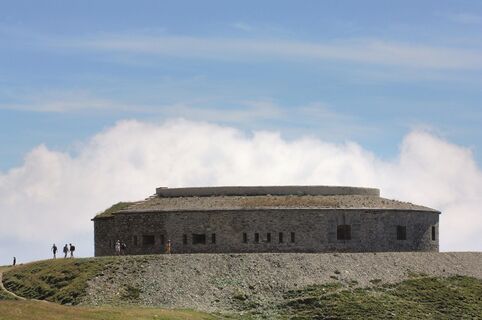
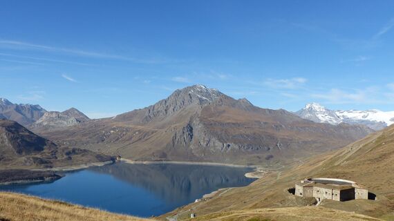
Saint-Pierre chapel marks the beginning of your journey. The sounds of the alpine herds echo the marmots' whistles in the distance. The terrace of the 2000 trail seems to trail off to infinity. In the background, the regal Roche d'Étache cuts the horizon. The stage is set for retracing the military history of Col du Mont Cenis. Give in to the temptation of taking various scenic breaks, made easy by the gentle terrain. Gain a little more height as you overcome the only difficulty of the day and then, take your seat! At almost 2,300 m of altitude, this circular fort is an infallible observation post! Though peace and quiet have reigned here for over half a century, you can still feel the weight of history. As far as the eye can see, ridges draw jagged lines across the sky, reflected in the turquoise waters of the lake. There's no doubt about it: the horizon is all yours!

Ruta
Chapelle Saint-Pierre
(2.086 m)
Lugar de culto
0,1 km
Entrée bunker
(2.314 m)
Entrada de la cueva
6,7 km
Issue de secours
(2.311 m)
Entrada de la cueva
6,7 km
Plan des Trois Fontaines
(2.292 m)
Corredor/terreno
7,3 km
Chapelle Saint-Pierre
(2.086 m)
Lugar de culto
12,8 km
Ruta
Mapa
The 2000 footpath around Fort de Ronce
medio
Senderismo
12,93 km
Chapelle Saint-Pierre
(2.086 m)
Lugar de culto
0,1 km
Entrée bunker
(2.314 m)
Entrada de la cueva
6,7 km
Issue de secours
(2.311 m)
Entrada de la cueva
6,7 km
Plan des Trois Fontaines
(2.292 m)
Corredor/terreno
7,3 km
Chapelle Saint-Pierre
(2.086 m)
Lugar de culto
12,8 km
Descripción de la

The time machine takes you back to the past of Italian soldiers. Grab front row seats on this terraced trail with breathtaking views. Seek out the best photo agnles and take your time diving into the history of this emblematic site.

Tecnología
n.d.
Condición
4 / 6
Paisaje
n.d.
Experiencia
n.d.
Autor
Logo
Compartir gira
Mapa
The 2000 footpath around Fort de Ronce
medio
Senderismo
12,93 km
Error
Se ha producido un error. Por favor, inténtelo de nuevo.
Información sobre la ruta
Ruta

To guide you in the field, consult the "step-by-step" directional diagram provided in pdf.

Viaje de ida

Información adicional y consejos
Información complementaria

The duration of hiking trails is calculated using reference paces: 300 m/h ascent, 500 m/h descent and 4 km/h on the flat.
As hazards may occur at any time on the routes, the GPX tracks provided are not contractual. They are given for information only. Riders use them at their own risk, depending on their level of technological proficiency and their understanding of the terrain.

Aún no hay opiniones
Escriba un comentario

Las opiniones ayudan a otros usuarios a elegir su próxima aventura. Por favor, valora solo el tour, no el tiempo o tu aperitivo.

Seleccione una de las estrellas para puntuar el recorrido
Mal tour
Gira débil
Visita mediocre
Buena visita
Excelente recorrido
bergfex logo Infórmate Siempre en directo con más de 9.500 webcams. bergfex Como usuario Pro, ahora puede ver las webcams correspondientes a muchos tours en la app de tours desde. Esto le permite ver las condiciones actuales directamente.
Senderismo y rastreo

Senderismo y rastreo

Senderismo y rastreo
Más de 550.000 sugerencias de excursiones, mapas detallados y un intuitivo planificador de rutas hacen de esta aplicación una herramienta imprescindible para todos los amantes de la naturaleza.
Senderismo y rastreo