Invierno
Verano
El tiempo
Webcams
Alojamientos
Excursiones
Historial de búsqueda
Sugerencias de búsqueda
No se han encontrado resultados
Buscar en
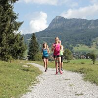
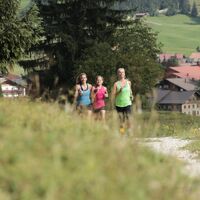
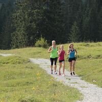
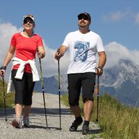
Running
Inicio
Verano Österreich
Tirol
Lechtal
Vorderhornbach
Excursiones
Running
Región
Alojamientos
El tiempo
Webcams
Consejos para el tiempo libre
Excursiones
Deporte
Lagos
Fotos
Vídeos
Ofertas
Proveedor de Deportes
Foro
Estación de esquí
Running
Vorderhornbach
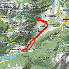
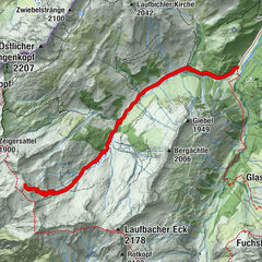
Mapa
mostrar
ocultar
Filtro de circuitos
Tipo de excursión
(Todos)
Nordic Walking (3)
Running (2)
Trailrunning (1)
Búsqueda de texto completo
Nivel
mín.
1 fácil
2 moderadamente
3 mediana dificultad
4 dificultad alta
5 muy difícil
6 extremo
máx.
1 fácil
2 moderadamente
3 mediana dificultad
4 dificultad alta
5 muy difícil
6 extremo
Técnica
mín.
1 fácil
2 moderadamente
3 mediana dificultad
4 dificultad alta
5 muy difícil
6 extremo
máx.
1 fácil
2 moderadamente
3 mediana dificultad
4 dificultad alta
5 muy difícil
6 extremo
Longitud (km)
Metros de altura
otros filtros
Buscar
Posponer
6 Excursiones.
ordenado por
Relevanz
Relevancia
längste Distanz
kürzeste Distanz
duración máxima
duración mínima
metros más verticales
menos metros verticales
alto estado
baja condición
alta tecnología
baja tecnología
Nombre A-Z
Nombre Z-A
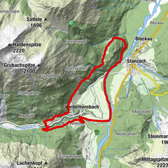
Vorderhornbach - 10km Hillclimb Baichlstein
medio
Trailrunning
10,09
km
01:00
h
192
hm
939 - 1.105
m
Técnica
Nivel
altitude route
difícil
Running
10,59
km
00:50
h
516
hm
1.668 - 1.890
m
Técnica
Nivel
Höhenstrecke (altitude route)
medio
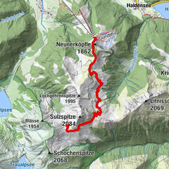
Nordic Walking
10,63
km
02:15
h
425
hm
1.669 - 1.895
m
Técnica
Nivel
Gaicht-Runde
difícil
Running
9,47
km
01:10
h
266
hm
1.073 - 1.222
m
Técnica
Nivel
Gaicht round
fácil
Nordic Walking
9,3
km
01:35
h
221
hm
1.077 - 1.223
m
Técnica
Nivel
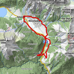
Am Lech entlang
medio
Nordic Walking
18,46
km
03:42
h
151
hm
852 - 969
m
Técnica
Nivel
Tous según tipos
Senderismo
Bike
Invierno
Alpino
Running
Agua
Motorsport
Nordic Walking
Running
Trailrunning
Touren nach Regionen
Lechtal
1214
Gipfeltouren in der Region
Hochvogel (2.592 m)
7
Gaishorn (2.247 m)
16
Rauhhorn (2.240 m)
4
Gaiseck (2.212 m)
5
Sulzspitze (2.084 m)
4
Rote Spitze (2.130 m)
4
Kreuzspitze (2.367 m)
7
Lachenspitze (2.130 m)
6
Gaichtspitze (1.988 m)
6
Krinnenspitze (2.000 m)
18
Excursiones opcionales por los alrededores
Breitenberg 1893 m
difícil
Senderismo
14,94
km |
1009
hm |
06:30
h
Skitour auf den Kleinen Seekopf in den Allgäuer Alpen
medio
Esquí de travesía
12,57
km |
981
hm |
04:15
h
Gondelbahn Neunerköpfle - Landsberger Hütte (1.805 m) bzw. Vilsalpsee
medio
Senderismo
11,87
km |
313
hm |
05:30
h
From the Vilsalpsee to the Landsberger Hütte
medio
Senderismo
9,51
km |
586
hm |
03:55
h
Vecinos
Elmen
Stanzach
Forchach
Häselgehr
Hinterhornbach
Regiones favoritas
Innsbruck
Lienz
Kufstein
Reutte
Imst
Tannheimer Tal
Neustift im Stubaital
Schwaz
Ischgl
Längenfeld - Huben - Gries
Telfs
Kals am Großglockner
Seefeld in Tirol
Matrei in Osttirol
Leutasch
Kaltenbach
Wörgl
Hall in Tirol
Umhausen im Ötztal
Jenbach
Sorteo
Produkt-Paket für die ganze Familie
Primavera XXL-Gewinnspiel
No se han encontrado entradas.
La búsqueda no está disponible actualmente.
Afine su búsqueda.
Resultados de la búsqueda local
(<= 25km)
Más resultados
(> 25km)
%count% Resultados de búsqueda
%name%
%type%
%elevation%
%population%
%lpButton%


, dahinter Schochen und Lachenkopf.")
 bzw. Vilsalpsee")