Hahlkogel 2655m - Längenfeld/Huben

Logotipo Hahlkogel 2655m - Längenfeld/Huben
Datos del tour
6,57km
1.201 - 2.615m
Distancia
1.414hm
20hm
Ascenso
04:30h
 
Duración
Breve descripción

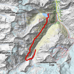
HUBEN FUSSBALLPLATZ -> direction Alpengasthof am Feuerstein -> direction Hahlkogelhaus -> HAHLKOGEL

Dificultad
difícil
Valoración
Técnica
Nivel
Paisaje
Experiencias
Ruta
Huben (1.198 m)
0,1 km
Ebenalm
3,9 km

La mejor temporada
ene
feb
mar
abr
may
jun
jul
ago
sep
oct
nov
dic
Punto álgido
2.615 m
Punto final

Hahlkogel

Perfil alto

Autor
La gira Hahlkogel 2655m - Längenfeld/Huben es utilizado por outdooractive.com proporcionado.

5,0
Valoración global

5

100

%

4

0

%

3

0

%

2

0

%

1

0

%

GPS Downloads
  • GPX GPS Exchange Format (XML)
  • KML Google Earth, Google Maps
Códigos de descarga QR para teléfonos móviles

Información general

Vistas panorámicas
Más circuitos por las regiones

Excursiones opcionales por los alrededores

Hohe Geige über Gawinden und den Westgrat

difícil Senderismo
14,27km | 1752hm | 08:30h

Amberger Hut

medio Senderismo
5,6km | 495hm | 02:15h

Larstigalm - Niederthai

fácil Senderismo
3,24km | 215hm | 01:00h

Fuldauer Höhenweg zum Taschachhaus

medio Senderismo
11,31km | 399hm | 04:00h