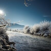
Invierno
Verano
El tiempo
Webcams
Alojamientos
Excursiones
Historial de búsqueda
Sugerencias de búsqueda
No se han encontrado resultados
Buscar en
Excursiones
Inicio
Verano Österreich
Steiermark
Ausseerland - Salzkammergut
Tauplitz
Excursiones
Región
Alojamientos
El tiempo
Webcams
Consejos para el tiempo libre
Excursiones
Deporte
Lagos
Fotos
Ofertas
Proveedor de Deportes
Foro
Estación de esquí
Excursiones
Tauplitz
Mapa
mostrar
ocultar
Filtro de circuitos
Tipo de excursión
(Todos)
Senderismo (277)
Sendero temático (10)
Mountain hiking (10)
long-distance walking trail (4)
Camino de peregrinación (2)
Speed-Hiking (2)
Mountainbike (22)
Ciclismo (12)
E-MTB (2)
E-Bike (1)
Ciclismo de carrera (1)
Running (17)
Trailrunning (17)
Nordic Walking (10)
Senderismo de invierno (16)
Esquí de travesía (12)
Raquetas de nieve (8)
Trineo (1)
Skiing (1)
Splitboard (1)
Excursión de alta montaña (5)
Vía ferrata (4)
Escalada (1)
Montar a caballo (4)
Búsqueda de texto completo
Nivel
mín.
1 fácil
2 moderadamente
3 mediana dificultad
4 dificultad alta
5 muy difícil
6 extremo
máx.
1 fácil
2 moderadamente
3 mediana dificultad
4 dificultad alta
5 muy difícil
6 extremo
Técnica
mín.
1 fácil
2 moderadamente
3 mediana dificultad
4 dificultad alta
5 muy difícil
6 extremo
máx.
1 fácil
2 moderadamente
3 mediana dificultad
4 dificultad alta
5 muy difícil
6 extremo
Longitud (km)
Metros de altura
otros filtros
Buscar
Posponer
440 Excursiones.
ordenado por
Relevanz
Relevancia
längste Distanz
kürzeste Distanz
duración máxima
duración mínima
metros más verticales
menos metros verticales
alto estado
baja condición
alta tecnología
baja tecnología
Nombre A-Z
Nombre Z-A
Eichleitenweg
fácil
Running
1,96
km
00:51
h
-
662 - 798
m
Técnica
Nivel
Bienenmuseumweg
fácil
Running
1,84
km
00:28
h
-
660 - 845
m
Técnica
Nivel
SNOOC - floodlight tobogganing on the Grafenwiese
fácil
Trineo
0,49
km
00:01
h
-
984 - 1.054
m
Técnica
Nivel
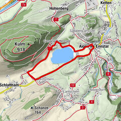
Rund um den Spechtensee
fácil
Senderismo
4,5
1,46
km
00:30
h
6
hm
1.052 - 1.067
m
Técnica
Nivel
Path through the nature reserve Laasen
fácil
Senderismo
3,68
km
01:00
h
6
hm
788 - 796
m
Técnica
Nivel
Small Enns round
Senderismo
3,22
km
00:45
h
7
hm
655 - 668
m
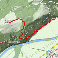
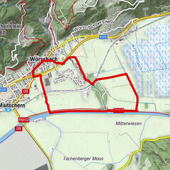
Wörschacherway and Enns-Moos-Way
fácil
Senderismo
4,6
km
02:00
h
8
hm
635 - 650
m
Técnica
Nivel
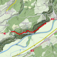
Enns- and Moosweg Wörschach
fácil
Senderismo de invierno
4,59
km
01:00
h
8
hm
635 - 650
m
Técnica
Nivel
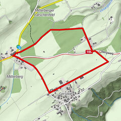
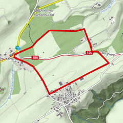
Movement Arena - Gersdorferrunde
fácil
Nordic Walking
2,61
km
45:00
h
10
hm
799 - 810
m
Técnica
Nivel
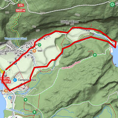
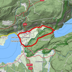
Vom Grundlsee zum Toplitzsee
Senderismo
3,2
3,2
km
01:00
h
10
hm
708 - 718
m
Técnica
Nivel
Gersdorferrunde
fácil
Running
2,58
km
00:23
h
11
hm
799 - 811
m
Técnica
Nivel
Puttererseerunde
fácil
Senderismo
3,65
km
00:55
h
11
hm
650 - 662
m
Técnica
Nivel
Circular hike from Gößl to Lake Toplitz
fácil
Senderismo
2,5
3,34
km
01:30
h
19
hm
709 - 732
m
Técnica
Nivel
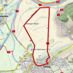
Winter hiking on the Moosrundwanderweg in Irdning
fácil
Senderismo de invierno
5,19
km
01:15
h
20
hm
638 - 671
m
Técnica
Nivel
Irdninger Moosroundtrail
medio
Running
6,25
km
00:55
h
20
hm
641 - 668
m
Técnica
Nivel
Irdninger Moss Hike
fácil
Senderismo
6,22
km
01:30
h
22
hm
638 - 672
m
Técnica
Nivel
Steyr Ursprung Baumschlagerreith
fácil
Senderismo
1,38
km
00:15
h
22
hm
724 - 738
m
Técnica
Nivel
Big Enns round
Senderismo
7,92
km
02:00
h
24
hm
651 - 678
m
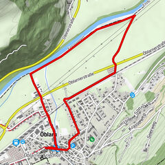
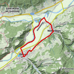
Large Enns Loop Öblarn-Niederöblarn
fácil
Senderismo de invierno
7,88
km
02:00
h
27
hm
651 - 678
m
Técnica
Nivel
Sonnenalm to the Singerhauserhütte
fácil
Senderismo
3,06
km
01:00
h
27
hm
830 - 874
m
Técnica
Nivel
Páginas:
1
2
3
4
5
6
7
8
siguiente
Tous según tipos
Senderismo
Running
Invierno
Bike
Alpino
Otros
Touren nach Regionen
Ausseerland - Salzkammergut
96
Gipfeltouren in der Region
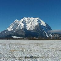
Grimming (2.351 m)
12
Kammspitz (2.139 m)
8
Multereck (2.176 m)
8
Großes Tragl (2.184 m)
7
Kleinmölbing (2.160 m)
9
Almkogel (2.116 m)
4
Kampl (1.685 m)
5
Hechlstein (1.815 m)
4
Winterstein (1.915 m)
6
Hochtausing (1.822 m)
5
Excursiones opcionales por los alrededores
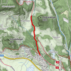
To the Top of the Gröbminger Kammspitze - elev. 2.139 m
difícil
Senderismo
11,63
km |
1318
hm |
06:00
h
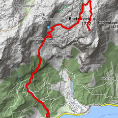
Backenstein
medio
Senderismo
9,96
km |
960
hm |
06:03
h
Wörschachklamm
fácil
Senderismo
4,67
km |
266
hm |
02:00
h
Grimming via Southeast degree
difícil
Senderismo
13,73
km |
1678
hm |
09:00
h
Vecinos
Tauplitzalm
Wörschachwald
Bad Mitterndorf
Öblarn
Stainach-Pürgg
Regiones favoritas
Graz - Stadt
Weiz
Leoben
Deutschlandsberg
Bad Aussee
Kapfenberg
Leibnitz
Liezen
Solarstadt Gleisdorf
Bruck an der Mur
Mariazell
Bad Mitterndorf
Knittelfeld
Eibiswald
Hartberg
Admont
Feldbach
Trofaiach
Eisenerz
Gröbming
Sorteo
Produkt-Paket für die ganze Familie
Primavera XXL-Gewinnspiel
No se han encontrado entradas.
La búsqueda no está disponible actualmente.
Afine su búsqueda.
Resultados de la búsqueda local
(<= 25km)
Más resultados
(> 25km)
%count% Resultados de búsqueda
%name%
%type%
%elevation%
%population%
%lpButton%