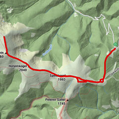
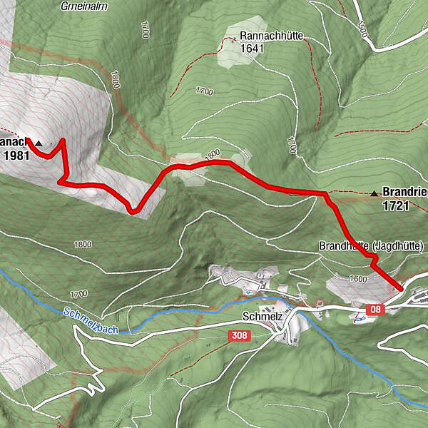
TÜPL Seetal auf die Hohe Ranach

Logotipo TÜPL Seetal auf die Hohe Ranach
Datos del tour
6,5km
1.624 - 1.970m
Distancia
419hm
419hm
Ascenso
02:30h
 
Duración
Breve descripción

einfache Wanderung für jeden geeignet

Dificultad
fácil
Valoración
Técnica
Nivel
Paisaje
Experiencias
Ruta
La mejor temporada
ene
feb
mar
abr
may
jun
jul
ago
sep
oct
nov
dic
Punto álgido
1.970 m

4,5
Valoración global

5

50

%

4

50

%

3

0

%

2

0

%

1

0

%

GPS Downloads
  • GPX GPS Exchange Format (XML)
  • KML Google Earth, Google Maps
Códigos de descarga QR para teléfonos móviles

Superficie de carretera

Asfalto
Gravilla
Pradera
Bosque
Roca
Expuesto
Más circuitos por las regiones

Excursiones opcionales por los alrededores

Vom Salzstiegl auf den Ameringkogel

medio Senderismo
14,22km | 755hm | 05:00h

Kreiskogel & Zirbitzkogel

difícil Senderismo
10,92km | 739hm | 04:30h

From the Waldheimhütte hut to the Zirbitzkogel

difícil Senderismo
14,34km | 794hm | 05:00h

Große 4-Seenrunde am Zirbitzkogel

fácil Senderismo
18,83km | 1014hm | 04:42h