

© Oststeiermark Tourismus - Birgit Kandlbauer

© Oststeiermark Tourismus - TV Jofglland-Waldheimat

© Oststeiermark Tourismus - TV Jofglland-Waldheimat
- Breve descripción
-
From the UNESCO World Heritage Site Semmering or from the high altitude health resort Fischbach to the edge of the Pannonian plain near Köszeg leads a path full of variety and attractions of nature: alpannonia®.
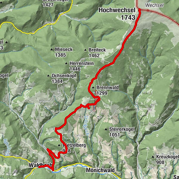
Another possibility would be to start the alpannonia long-distance hiking trail in Waldbach. A yellow marked alpannonia feeder trail then leads you to the Hochwechsel. This stage joins the main alpannonia trail and nothing stands in the way of unlimited hiking pleasure.
- Dificultad
-
medio
- Valoración
-
- Ruta
-
Pfarrkirche hl. Georg0,0 kmWaldbach0,1 kmSchmiedviertel4,1 kmOchsenloch Hütte9,2 kmGemeindkreuz11,4 kmKaltwiesen Hütte12,3 kmWetterkoglerhaus16,4 kmHochwechsel (1.743 m)16,4 km
- La mejor temporada
-
enefebmarabrmayjunjulagosepoctnovdic
- Punto álgido
- 1.733 m
- Punto final
-
Wetterkoglerhaus on the Hochwechsel
- Perfil alto
-


- Autor
-
La gira "alpannonia" - feeder: Waldbach - Hochwechsel es utilizado por outdooractive.com proporcionado.
GPS Downloads


Información general
Punto de avituallamiento
Vistas panorámicas
Más circuitos por las regiones
-
Hochsteiermark
4066
-
Joglland - Waldheimat
1506
-
Waldbach-Mönichwald
302


