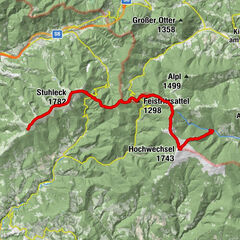
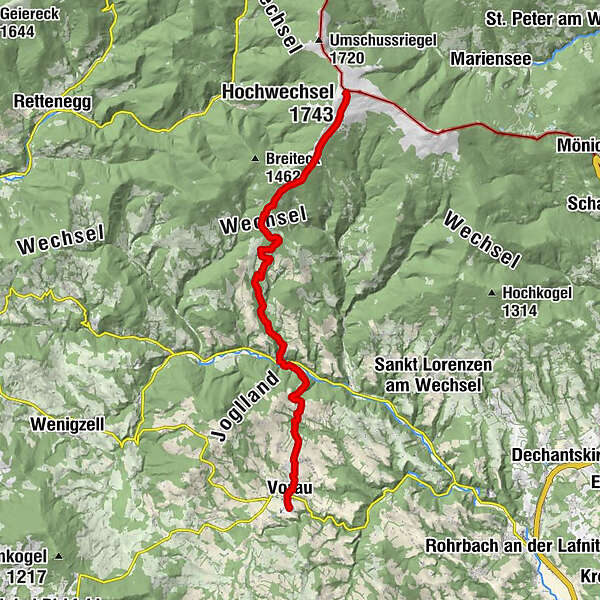
"alpannonia" - feeder: Vorau - Mönichwald - Hochwechsel


© Oststeiermark Tourismus - Birgit Kandlbauer

© Oststeiermark Tourismus - Birgit Kandlbauer

© Oststeiermark Tourismus - Birgit Kandlbauer

© Oststeiermark Tourismus - Birgit Kandlbauer

© Oststeiermark Tourismus - TV Joglland-Waldheimat
- Breve descripción
-
From the UNESCO World Heritage Site of Semmering or the high-altitude health resort of Fischbach to the edge of the Pannonian plain near Köszeg, a trail full of variety and attractions of nature leads: alpannonia®.
It is also possible to start the alpannonia trail, as in this case, in Vorau or Mönichwald and hike from there to the 1743 m high Hochwechsel. From there, the main trail continues to Mönichkirchen, Hochneukirchen, Bernstein, Oberkohlstätten and finally to the destination, Köszeg.
- Dificultad
-
difícil
- Valoración
-
- Ruta
-
Kutscherwirt Hotel-Restaurant0,2 kmGasthof Pension „Vorauerhof“0,5 kmVorau0,6 kmFilialkirche Marktkirche hl. Ägydius0,6 kmRiegersbach2,0 kmWeißenbach3,8 kmLandhotel Mönichwalderhof6,6 kmMönichwald6,6 kmPfarrkirche hll. Peter und Paul6,7 kmUnter der Alm10,3 kmBerggasthof Schwengerer11,2 kmOchsenloch Hütte12,3 kmGemeindkreuz14,6 kmKaltwiesen Hütte15,5 kmHochwechsel (1.743 m)19,5 km
- La mejor temporada
-
enefebmarabrmayjunjulagosepoctnovdic
- Punto álgido
- 1.733 m
- Punto final
-
Wetterkoglerhaus on the Hochwechsel
- Perfil alto
-


- Autor
-
La gira "alpannonia" - feeder: Vorau - Mönichwald - Hochwechsel es utilizado por outdooractive.com proporcionado.
GPS Downloads


Información general
Punto de avituallamiento
Cultural/Histórico
Vistas panorámicas
Más circuitos por las regiones
-
Wiener Alpen
3036
-
Joglland - Waldheimat
1506
-
Waldbach-Mönichwald
302