Arthurhaus - Bürglhöh (Bischofshofen)

Logotipo Arthurhaus - Bürglhöh (Bischofshofen)
Datos del tour
7,09km
797 - 1.518m
Distancia
14hm
707hm
Ascenso
02:05h
 
Duración
Breve descripción

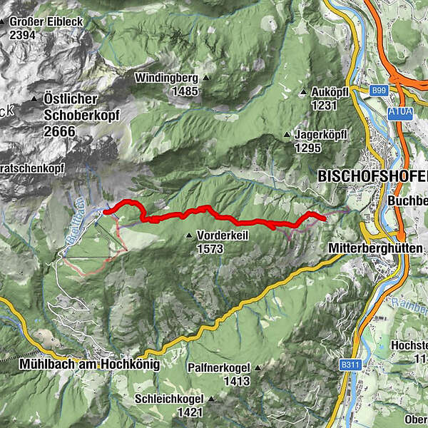
Hike along the marmot trail to Gasthof Bürglhöh and on to Bischofshofen to the ski jump area.A hardly strenuous hike for connoisseurs!

Dificultad
fácil
Valoración
Técnica
Nivel
Paisaje
Experiencias
Ruta
Arthurhaus
Gasthof Bürglhöh
6,9 km

La mejor temporada
ene
feb
mar
abr
may
jun
jul
ago
sep
oct
nov
dic
Punto álgido
1.518 m
Punto final

Bischfoshofen

Perfil alto

Autor
La gira Arthurhaus - Bürglhöh (Bischofshofen) es utilizado por outdooractive.com proporcionado.

Valoración global

5

0

%

4

0

%

3

0

%

2

0

%

1

0

%

Error
Se ha producido un error. Por favor, inténtelo de nuevo.
Gracias por su comentario

Se ha eliminado la calificación

GPS Downloads
  • GPX GPS Exchange Format (XML)
  • KML Google Earth, Google Maps
Códigos de descarga QR para teléfonos móviles

Información general

Punto de avituallamiento
Más circuitos por las regiones

Excursiones opcionales por los alrededores

Summit tour Taghaube

difícil Senderismo
6,25km | 768hm | 03:00h

Maria Alm - Riemannhaus

Senderismo
3,99km | 1073hm | 05:00h

Pfarrachhöhe ab Gries

medio Senderismo
11,14km | 1196hm | 05:24h

Wanderung zur Ostpreußenhütte in Werfen (1.630 m)

medio Senderismo
11,23km | 726hm | 04:30h