© c-Salzburg Land Tourismus
- Breve descripción
-
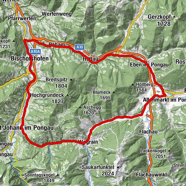
Distance: 51,4 km
Lowest / Highest point: 538m / 957m
Sum of all ascents: 590 hm
Wagrain tourist office – Reitdorf – Eben – Hüttau – Pöham – Bischofshofen – Mitterberghütten – St. Johann im Pongau – Wagrain tourist office
- Dificultad
-
medio
- Valoración
-
- Ruta
-
Markt0,1 kmFilalkirche Hl. Franziskus („Marktkirche“)0,1 kmWagrain0,3 kmWagrain0,5 kmHof1,0 kmMoos1,9 kmHubdörfl2,7 kmSchwaighof3,4 kmMoadörfl4,7 kmMoawirt4,7 kmScharfettkapelle7,7 kmFeuersang8,1 kmGh. Schützenhof8,7 kmReitdorf9,0 kmSinnhub12,8 kmEben im Pongau15,4 kmSchwaiger15,4 kmSteiner's15,6 kmGasthof Ebnerwirt15,7 kmEben im Pongau15,9 kmImbiss Wieser16,2 kmGasthof Brunnhaeusl19,9 kmPostwirt "Darijo"23,1 kmFritztalstube23,2 kmHüttau23,3 kmPöham27,8 kmBischofshofen34,1 kmBischofshofen34,2 kmPfarrkirche St. Maximillian34,6 kmPizzeria37,1 kmEvang. Annakapelle42,6 kmSankt Johann im Pongau42,6 kmPfarrkirche St. Johann42,8 kmGasthof Grubhöhe45,4 kmGoldanger50,9 kmFilalkirche Hl. Franziskus („Marktkirche“)51,2 kmMarkt51,2 kmWagrain51,3 km
- La mejor temporada
-
enefebmarabrmayjunjulagosepoctnovdic
- Punto álgido
- 956 m
- Punto final
-
Wagrain tourist office
- Perfil alto
-


-

-
AutorLa gira Gründeck circular route es utilizado por outdooractive.com proporcionado.
GPS Downloads


Información general
Punto de avituallamiento
Cultural/Histórico
Vistas panorámicas
Más circuitos por las regiones
-
Salzburger Sportwelt
45
-
Hüttau
26