Reisach - Reißkofelbad

Logotipo Reisach - Reißkofelbad
Datos del tour
7,11km
652 - 1.007m
Distancia
345hm
335hm
Ascenso
01:15h
 
Duración
Breve descripción

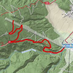
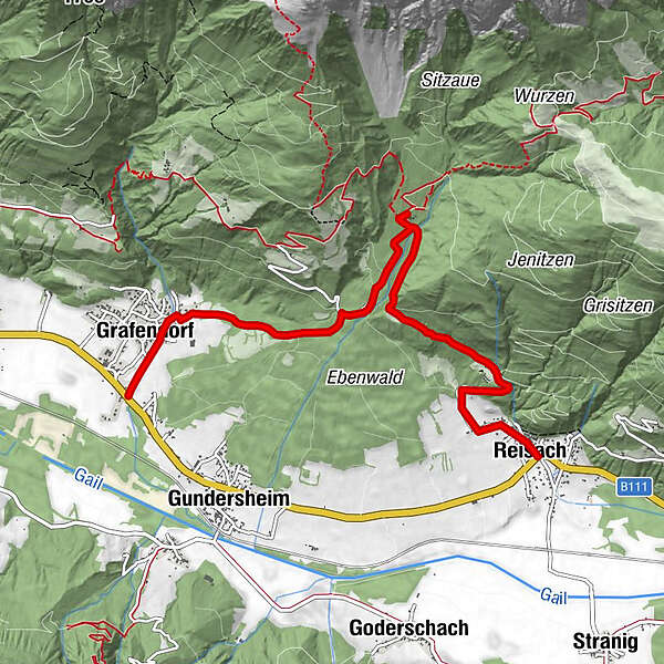
Von Reisach über Gemeindestraße zum Reißkofelbad. Möglichkeit vom Reißkofelbad über Gemeindestraße hinunter nach Grafendorf.

Dificultad
fácil
Valoración
Técnica
Nivel
Paisaje
Experiencias
Ruta
Gasthaus Augstan
0,0 km
Reisach
0,0 km
Pfarrkirche Sankt Peter und Paul
0,2 km
Schönboden
1,3 km
Rinsenegg
2,3 km
Reißkofelbad
3,3 km
Grafendorf
6,6 km

La mejor temporada
ago
sep
oct
nov
dic
ene
feb
mar
abr
may
jun
jul
Punto álgido
1.007 m
Punto final

Reißkofelbad

Perfil alto

Autor
La gira Reisach - Reißkofelbad es utilizado por outdooractive.com proporcionado.

Valoración global

5

0

%

4

0

%

3

0

%

2

0

%

1

0

%

Error
Se ha producido un error. Por favor, inténtelo de nuevo.
Gracias por su comentario

Se ha eliminado la calificación

GPS Downloads
  • GPX GPS Exchange Format (XML)
  • KML Google Earth, Google Maps
Códigos de descarga QR para teléfonos móviles

Información general

Vistas panorámicas

Excursiones opcionales por los alrededores

Eislaufen Rundbahn westlicher Seeteil

medio Senderismo de invierno
3,78km | 3hm | 00:55h

Winterwanderweg entlang der Obergailtaler Panoramaloipe - Bereich G...

fácil Senderismo de invierno
5,02km | 3hm | 01:27h

Jenig-Kreuth-Guggenberg-Möschach-Hermagor

medio Senderismo de invierno
14,49km | 528hm | 05:30h

Von Weissbriach auf die Berggeisthütte

fácil Senderismo de invierno
2,51km- | 00:46h