- Breve descripción
-
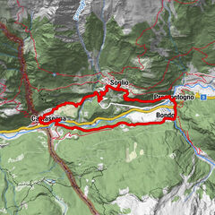
Hike on mainly flat paths and little roads all the way around Lake Sils. With plenty of views of the lake and the surrounding peaks.
- Dificultad
-
medio
- Valoración
-
- Ruta
-
Plan Cuncheta0,4 kmIsola (See) (1.810 m)2,2 kmIsola (1.811 m)3,0 kmIls Barchiröls4,6 kmSils/Segl Maria Barchiröls (1.802 m)4,7 kmSils im Engadin (1.803 m)5,2 kmPizs5,5 kmClos5,6 kmMutals5,7 kmDotturas5,7 kmSan Lurench6,0 kmPignoulas6,2 kmGrevasalvas (1.941 m)9,5 kmBlaunca (2.037 m)10,8 kmCapolago13,2 kmMaloja (See) (1.803 m)13,3 km
- La mejor temporada
-
enefebmarabrmayjunjulagosepoctnovdic
- Punto álgido
- 2.035 m
- Punto final
-
Maloja
- Perfil alto
-
 © outdooractive.com


- Autor
-
La gira Circuit around Lake Sils es utilizado por outdooractive.com proporcionado.
GPS Downloads


Más circuitos por las regiones
-
Veltlin / Valtellina
852
-
Engadin St. Moritz
782
-
Isola
282